Predictive Vision

Predicting electric-shock accidents from driving footage

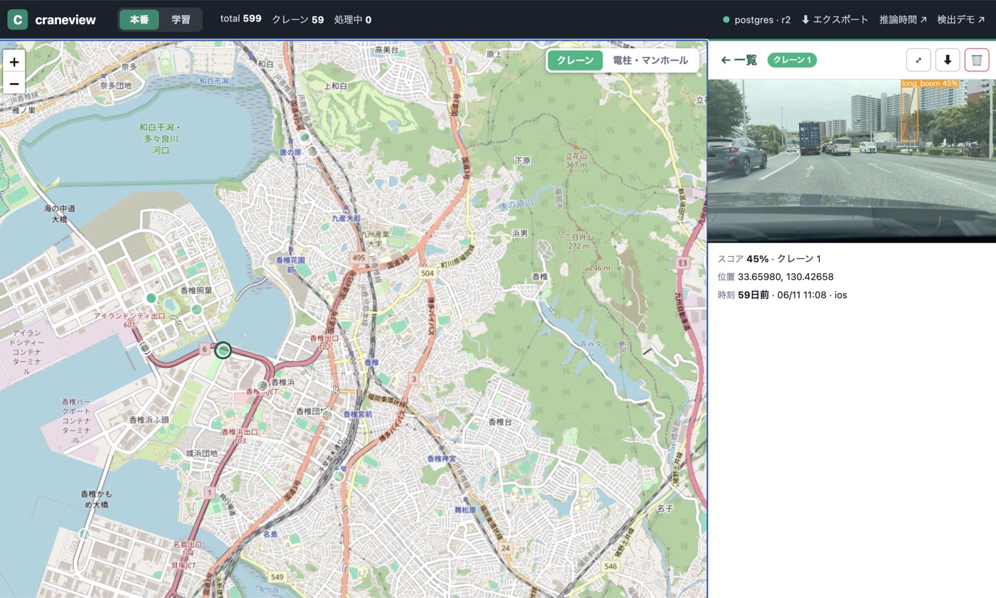
Put one phone on the dashboard of a company car that already drives the city every day, and that driving becomes detection coverage. AI on the phone spots crane trucks and extended booms and uploads only the few frames a boom appears in. The management app groups observations taken nearby and close in time into one worksite — a single pin on the map, and one printable report for the day.

Predicting electric-shock accidents from driving footage
Field demo, Fukuoka59 detection events
Breakdown27 long boom · 28 truck crane · 4 excavator arm
On-device classestruck crane, long boom, concrete pump, excavator arm
OutputMap · list · printable daily report

The 59 events are what the model logged during a live drive — not 59 hand-verified hazardous sites, and not an accuracy figure. What it detects and what it misses in real operation is what the trial is for.

01 Problem / Opportunity

What is missing is not the accident — it is knowing the worksite exists

When a crane boom or wire touches an overhead line, an electric-shock accident and an outage happen at the same moment. From the utility's side, though, the dangerous work is not the work they know about — it is the work nobody told them about.

Unreported workAdvance notification never covers everything: unannounced jobs, sudden add-on work, one-off subcontractor tasks.
Patrol has a ceilingCovering an entire service area by human patrol is not realistic in either cost or time.
Vehicles already drivePatrol cars and company vehicles cross the service area every day. That movement is not yet used for detection.
The opportunityDriving × a smartphone = area-wide coverage with no extra driving cost and no installation work.
02 Value Proposition

Drop in a phone, get a map of the sites worth checking

This is not a system that declares an accident. It is first-pass screening that gathers, early and widely, the sites a person should look at — leaving the judgement with the people who own the operational standard.
Zero driver workloadA passive design: the phone is fixed to the dashboard and runs by itself. The app is touched before departure and after stopping, never while driving.
Misses weigh moreFor outage prevention a missed site costs more than a false one, so recall is tuned first and false positives are traded down afterwards.
Light on data and privacyContinuous footage never leaves the phone. Only the minimum images plus position and time are uploaded, at the moment something is detected.
Output people can useMap pins, a reviewable list, and a one-day report that prints straight to a submittable PDF.
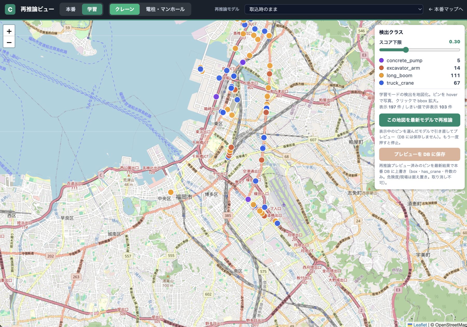
A map of Fukuoka covered in detection pins, coloured by class, with a legend counting each class
Detections from driving around Fukuoka, plotted on the map and coloured by class. Hovering a pin shows the photo; clicking it opens the detection. The slider on the right hides low-scoring detections, so the operator decides how much to look at. Map data © OpenStreetMap contributors
03 Underlying Magic

Edge AI that takes the cost out of watching

Streaming every frame to the cloud makes bandwidth, storage and inference the dominant cost, and grows with every hour driven. The phone narrows a drive down to the few frames worth sending, so cost scales with detections instead of with driving time — and the server turns those few frames back into worksites.
Off-the-shelf is not enoughA stock YOLO model does not detect Japanese crane trucks, and it certainly cannot pick out the extended boom on its own. We label our own footage and fine-tune the model until it can — that is what makes the rest of this possible.
On-device modelA segmentation YOLO, converted to Core ML, runs on the phone. It tells apart four kinds of equipment — truck crane, long boom, concrete pump and excavator arm — chosen because each of them can reach an overhead line. Detection keeps running where there is no signal.
Upload gateProduction mode uploads only when a track is stable and a boom appears in the same frame, so an hour of driving with nothing in it costs almost nothing. A separate training mode uploads everything and feeds retraining.
Site clusteringThe server re-runs the same weights on what arrives, then clusters observations by GPS proximity and time window. Passing one site five times reads as one pin, not five.
Daily reportThe day is cut by capture time, not ingest time, and counts come from detected class names rather than a profile-dependent flag. Summary, hourly graph, class breakdown, site map and list, top-scoring images — one page.
Improvement loopRare poses and backgrounds are bootstrapped with 3D and synthetic data, then judged against real driving data. Label → dataset export → GPU training → the same weights shipped to iOS, server and browser, as one routine.
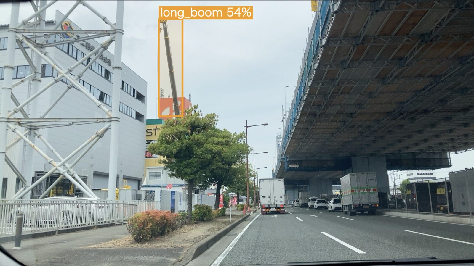
A street scene from a moving vehicle, with the extended boom boxed and labelled long_boom at 54%
An ordinary frame from an ordinary drive, as the model on the phone reads it. The extended boom is boxed as long_boom; 54% is the model's confidence in that one box, not a system-level accuracy figure. In production mode the frame is uploaded only once a box like this holds steady across frames.
04 Business Model

Start small, decide from the numbers

How much outage risk this removes cannot honestly be estimated up front. Start with a few vehicles for a few weeks and turn it into real numbers — how much ground got covered, how much time the checking took — then decide together what it is worth.

The trialFive iPhones in vehicles that are already driving, for a few weeks. How many of the real sites were found, how many false alarms come up per vehicle per hour, whether the same site keeps reappearing, and how long it takes from a detection to someone checking it. Those numbers are reviewed weekly and the settings adjusted while it runs.
Ways to payA setup fee plus a monthly fee per vehicle. It can also be built inside your own environment, or taken on together as a joint business. What shifts the shape: where the data is allowed to sit, how much of the running you want us to handle, and how many things you want detected.
Where the money goesDevices, mobile data, server processing and storage, and the staff time spent checking. The driving itself costs nothing extra, because the vehicles are on the road anyway. All of it gets measured during the trial and itemised.
Adding a targetDetecting something other than cranes reuses the same vehicles and the same footage. What is new each time is deciding what counts as the target, and training and checking the model for it — not building another capture network.
05 Go-to-market Plan

One drive, many ledgers

Power distribution is the way in, but the core technology is object detection at the edge. What the phone in an already-moving vehicle looks for can be swapped, so cranes are not where this stops.

Step 1 — Power distributionCranes and long booms, already driven live in Fukuoka. What counts as a site worth visiting, and the data to judge it by, get decided together during the trial.
Step 2 — Same drive, new targetsUtility poles, transformers and manholes for asset inspection; road surface damage, faded markings, signage, abandoned objects. Every added target is another ledger built from footage already being captured.
Step 3 — Anyone with a fleetMunicipalities (road and infrastructure inspection), construction and logistics (safety management), telecom, gas and water (asset patrol), insurance (risk assessment). The common condition is simple: vehicles that cover the same ground every day.
What is defensibleYOLO and the iPhone are available to anyone; a stock model detecting nothing useful here is exactly the point. The difference is the labelled data that gets it to Japanese crane trucks and booms, synthetic generation for the rare cases, the loop from on-device detection through review and retraining, and being close enough to Kyushu to drive out and fix what fails.
06 Where it stands

What runs today, and what we settle together

The prototype is deployed and has been driven on public roads in Fukuoka. What it has not yet met is somebody else's data, somebody else's security requirements, and somebody else's definition of a site worth visiting.

RunningDetection of the four kinds of crane on the iPhone itself, recording of image, position and time, the grouping of nearby observations into one worksite, the map, list and detail screens, and the printable daily report. All of that runs today.
To settle togetherAccuracy against your own operational data, connecting to the systems you already use, who gets told and what they do next, how long images are kept and whether faces and plates are blurred and who may see them, and the second thing to detect after cranes.